About This Site
The development of this web component, focusing on the Berlin Heights Addition neighborhood, was prepared under contract with the New Hampshire Department of Transportation (NHDOT). It is intended to serve as mitigation for the relocation of NH Route 110 through the historic neighborhood which resulted in the state acquiring and demolishing more than thirty structures along the route.
The neighborhood of Berlin Heights Addition, also known as “The Avenues” was designed and platted in a grid pattern in 1892-3 to accommodate the growing need for workforce housing.
Project Area Forms & Reports
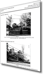 This section is comprised of the Project Area Forms prepared for NHDOT by Preservation Company in 2002 and 2008 for the Berlin Heights Addition Historic Area as well as the individual reports prepared to document twenty-eight properties prior to their demolition. The web pages have been styled to closely resemble the original forms they were created from while providing easier movement for the web user.
Charrette Book
In April 2011 a two-day design charrette/brainstorming session was
held in Berlin led by Jeffrey H. Taylor and Associates of Concord, bringing together design professionals, local citizens and officials, and representatives from NHDOT, the NH Division of Historical Resources and NH Preservation Alliance to address project issues. This booklet includes the sketches, concepts, and strategies generated by the charrette. This is a PDF document, Please see tips for viewing PDF's online in Site Usage Tips.
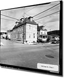 These large format photos were taken by Charley Freiberg of Ekins, New Hampshire to document the selected Level 3 historic properties prior to demolition. The images are presented, by street or avenue, as collections of thumbnails. Clicking on any of these thumbnail images opens a larger copy of that image in a viewer capable of displaying them one at a time or as a self-running slide show. Note: the photos for the Level 1 properties are located within each respective report.
 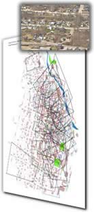 These aerial photos were taken in April 2010 by Preservation Company, prior to the beginning of building demolition, to document the landscape and/or neighborhood setting in the Berlin Heights Addition Historic District. The “photo map” is a PDF map with locations linked to associated aerial photos. The linked locations are shown by numbers within red boxes. Clicking on any of these boxes will open the associated neighborhood aerial photograph.
  built-in search function along with on-page search tools found in popular web browsers.