Berlin Heights Addition... continued
With the layout of the Avenues, West Milan Road (NH Route 110) was rerouted to fit into the grid that was designed. Instead of winding its way along the Dead River and the railroad tracks, NH Route 110 now follows Green Street to Second Avenue, turned onto Madigan Street, then onto Third Avenue and then followed Wight Avenue toward Milan.
Shortly after the subdivision plans for this area were on file, people began purchasing lots. One entire block, Block A (adjacent to the railroad track and south of Green Street), was sold to Lyman U. Cole, a local mason, and it is indicated as such on the plan. Approximately sixteen transactions were filed with the county in 1892. Often people purchased more than a single lot. Sometimes, as in the case of Fred Stevens, people purchased several contiguous lots. Other times, they bought individual lots in different blocks, such as T.H. Madigan, Jr. did. Land in this area continued to sell through the first decade of the twentieth century.
The first construction in the area began in August 1892. Local papers published accounts that Fred Stevens, W.C. Perkins and Frank Colby were building rental units in this area and by the end of the year seven residences were complete (Berlin Independent October 12, 1892). Fred Stevens, a native of Shelburne, New Hampshire, was a proprietor in Stevens & LePage Livery and Boarding Stable, founded in 1885. Stevens was also employed in real estate endeavors and in 1890 was attributed with owning twenty-three tenements in Berlin (Bacon 1890:83).
Nearly one year after Plan D was laid out; Plan E was added in April 1893. This area extends from present day Second Avenue to the rear lot lines of properties fronting Fifth Avenue. The southern terminus is Mt. Forist Street and the northern terminus is present day Wight Street. This is the earliest map or plan in which Third Avenue is shown, and although the plans are not to scale, it is noticeably wider than the other avenues laid out. The reason for this is unknown. Third Avenue is the only "grand boulevard" in the city, and is often referred to as Broad Street on maps of the area. Although they were not all built as planned or at the same time, this plan indicates that the intermediary east-west streets such as Jolbert, Sessions, Madigan, Mannering, and Hinchey Streets were laid out in 1893. Petitions to build Jolbert Street and Second Avenue were included in the 1898 city annual report. Like the previous plan, this one was divided into twenty-one blocks (30- 50), each with individual and uniform rectangular lots, where space would allow. Unlike the earlier plan, which showed purchasers buying individual lots and small groups of lots, Plan E had people buying larger groups (five or more) of lots or even entire blocks. Within the project area for instance, Cyril Brooks, a wood dealer, purchased nine lots at the corner of present day Hinchey Street and Third Avenue (Deed Book 69, Page 24). John Mitchell purchased all of Block 48, bounded by Forth and Fifth Avenues, Hinchey Street and Wight Avenue (Deed Book 69, Page 41).
Later in 1893, Plan E was expanded and modified to include thirteen more blocks (47-59), encompassing the numbered avenues from Third to Eighth Avenue. (Seventh and Eighth Avenues were never constructed.) John Mitchell purchased all of Blocks 48, 54, and 59 (Deed Book 69, Page 41). J. Howard Wight, a lawyer, was also a major landholder in this area; he purchased four lots in Block 50, and all of Blocks 51, 52, and 53 (Deed Book 69, Page 2).
Berlin Heights Addition added three plans after Plan E. Plans F and G were also filed in 1893 and cover the areas south and west of Plan E. The last plan, Plan H filed in 1907, laid out the area between the railroad tracks and the Dead River, north of present day Hillside Avenue.
Many of those who purchased large amounts of land in the area were employed in the building trades or closely related fields. Augustine N. Gilbert, (born in Waterville, Quebec in 1857) was a prominent contractor and builder who purchased a group of building lots along Second Avenue across from its intersection with Green Street in 1896. Gilbert had established himself in the building trades upon settling in Berlin in 1885, and the list of buildings that he constructed in Berlin includes: the Berlin National Bank, the Berlin Savings Bank and Trust Company building, the Superior Courthouse, and several private residences. He also owned and lived in the Gilbert Block on Main Street, until it was destroyed by fire in 1892 (Anonymous 1902:259).
Another local developer who purchased lots in the project area was Gershon Bickford. Born in New York City, Bickford settled in Berlin in 1890 and began a real estate and insurance business. Most notably, he purchased the Dead River Pond and drew off the water, which left him seven acres of desirable building land (Moses 1893:457).
City directories indicate that others who purchased lots in the project area included: W.L. McGivney, a carpenter; Ernest McCourt Macy, a civil engineer and city engineer in 1898 (he was also responsible for the laying out of some of the Berlin Heights Addition plans as part of Pike, Perkins and Macy, a civil engineering firm); and Charles Jolbert, a mason and lime and cement dealer. Other purchasers included: John Campbell, a grocer; Alfred Buckley who owned a billiards and pool hall; and Napoleon Rouleau, a tobacconist. John D. Lary, born in Dummer, New Hampshire, in 1850, had several businesses in Berlin at various times including a stage route between Berlin and Milan, an ice business, a livery, and a soda water bottling company. His biographical sketch stated that he was an "active speculator in real estate and has realized good profits" (Anonymous 1902:356).
Successful development and realization of the subdivision plans of Berlin Heights Addition was not immediate. Deed records indicate that in the first few years after the incorporation of the Berlin Heights Addition there was a steady increase in sales from thirteen in 1891 to fifty in 1892. Property sales peaked in 1893 with approximately 114 transactions. The following year, there was only half as many and the rate never regained the same level. After the turn of the twentieth century, annual sales of land dropped into the single digits. Limited sales continued through the 1930s. The Berlin Heights Addition was not listed in deed transactions after 1941. The exact date of dissolution of the corporation is unknown.
Residential construction and settlement of the project area was gradual. Overall, it appears that people who purchased more than one parcel later sold a majority of the lots undeveloped, speculatively building on only a few. Cyril Brooks, who purchased many parcels in the project area in 1893, sold most of his undeveloped lots that same year or the following year. By 1897, however, he was selling houses (Deed Book 90, Page 177). Anyone with money at this time in Berlin was investing in land and buildings attempting to capitalize on the rapid growth of the city (Upham- Bornstein 2003).
Public buildings such as a Methodist Episcopal Church at the corner of First Avenue and Mt. Forist Street (ca. 1895), and a grammar school at the corner of Sessions Street and Second Avenue were soon established in the area (Davis 1897:122). Sanborn maps indicate that the Sessions School was closed by 1914 and another elementary school was constructed just outside of the project area in 1916. The later Bartlett School and Mt. Forist M.E. Church are still in use.
ca.1900–ca.1920: Berlin Heights Addition and Citywide Continued Growth; Realization of Berlin Heights Addition Plan; Urban Neighborhood Develops
The first decade of the twentieth century saw continued population growth and development of the Berlin Heights Addition area. In 1900 the population of the approximate project area was 918. Citywide, the population between the previous decade and 1900 more than doubled to about 8890 (Arsdel 1934:4). This marked the end of the population boom that Berlin had experienced over the previous thirty years.
The 1900 census, the first census taken after the incorporation of Berlin Heights Addition in 1891, provides the best picture of how the project area developed. Streets lying in the project area and counted in the 1900 census included: First, Third (or Broad Street), Fourth, and Fifth Avenues, as well as Mt. Forist, Jolbert, and Madigan Streets. Second Avenue is not identified on the census. A self-sufficient neighborhood soon developed with new shops and services, like beauty parlors, opening throughout the early part of the twentieth century (Bureau of the Census 1900; Anonymous 1904). The Chick Brothers Shoe Factory began operation on Gilbert Street, adjacent to the railroad tracks in 1897. The most prevalent occupation in the project area in 1900 was shoemaker, but this was short-lived as the factory was closed by 1905.
Third Avenue was the most populated street in the project area with approximately 246 residents living in thirty-six dwellings (an average of 6.8 people per dwelling). Fifth Avenue was the least populated with approximately thirty-five residents. A majority of the residents, approximately 185 people, were first generation French-Canadians. The building stock was largely single family. There were approximately twenty two-family homes, and only a few three- or four-family dwellings. There were more renters than homeowners listed in the census, which indicates that many of the homes were built speculatively to house the burgeoning work force. Approximately 122 houses were constructed between the initial development of the neighborhood in 1892 and 1900 (Bureau of the Census 1900).
Residents were employed in the various mills in the city and approximately thirty residents of the project area were employed in the building trades (Bureau of the Census 1900). City directories from this period (1903-04) indicate that International Paper Company and the Berlin Mills Company employed about equal numbers. A few residents of this neighborhood worked for the Burgess Sulphite Fibre Company.
The industrial and commercial base in the vicinity of the project area continued. At the turn of the twentieth century, services and small businesses located within the neighborhood included three grocery stores, one each on First, Second, and Third Avenues and a public carriage company on Fourth Avenue (Berlin City Directory 1903-04).
Development of the Berlin Mills Company culminated in the construction of the Cascade Mill south of Berlin on the Berlin-Gorham town line in 1904 (Anonymous 1929:41). At that time, it was the largest self-contained paper making operation in the world and was equipped with the world's largest chemical pulp mill and paper machines (Anonymous 1929:41-42; Wight 1967:354). Much of the construction was done by Italian laborers, and housing was built nearby for workers, creating a small mill village known as Cascade (Wight 1967:356).
As new mills opened around the turn of the twentieth century, people began working in the Cascade and Riverside Mills as well and the distribution of mill employment shifted until all of the mills were almost equally represented by the skilled workers living in the project area. All of the mills were either within walking distance or located within an easy commute along the street railway line, such as Cascade Mills near the Gorham town line.
In the downtown new, large, architect-designed business blocks and public buildings were erected following fires in 1903, 1905 and 1909 (Closs 1997). Several theaters opened in the early 1900s. A public library was built in 1903, the Superior Courthouse in 1906, a new City Hall in 1914 and a new post office ca. 1920 (Closs 1997; Berlin Heritage Trail Partnership 1997). A street railway, running between Berlin and Gorham, began operation in 1902.
Between 1900 and 1910 as many as seventy-eight houses were constructed in the vicinity of the project area (Bureau of the Census 1910). By 1910, six new streets had developed in the project area, including north-south running Gilbert Street and Sixth Avenue. Sixth Avenue and its inhabitants were listed in the 1903-04 city directory. Gilbert Street was constructed or named as such around 1905 (Sanborn 1905; Anonymous 1906). New east-west intermediary streets were Hamlin, Sessions, and Mannering Streets. They were laid out but not named as of 1905 (Sanborn 1905). They first appeared (Session Street as Jewell Street) in the city directory of 1909-10 (Anonymous 1909-10). West Milan or Old Jericho Road, (NH Route 110) was now called Wight Street in the 1909-10 city directory. The upper part was known as Wight Street, and the lower end, near Third Avenue was called Wight Avenue.
As of 1901 the approximate population of the project area vicinity was 1,410 residents. Citywide, the population had grown to approximately 11,750, an increase of just over 3,000 residents in a decade (Arsdel 1934:4). In the project area, First Avenue had replaced Third Avenue as the most populated street. The numbers of native-born and French-Canadian born residents were nearly equal, and a number of Italian, Russian, and Russian Jews were living in the neighborhood as well. Single-family dwellings were still the most popular housing types. However numbers of, two-, three-, and four or more-family housing types were also increasing. In 1910 there were nine three- family dwellings, four of them on Third Avenue. There were four four-family dwellings on First Avenue. The number of rented dwellings outnumbered owner-occupied dwellings.
Most of the inhabitants of this neighborhood worked as laborers in any one of the five mills in operation in Berlin at the time. Retail owner or clerk were the second and third most frequent occupations in this neighborhood, followed by the building trades (Bureau of the Census 1910).
Berlin was strongly impacted by the 1911 Weeks Act establishing the White Mountain National Forest. Logging operations in the region suffered from the large forest fires which were the impetus for the Weeks Act. The Brown Company offered the government nearly 38,000 acres of land, encompassing a large portion of the Presidential Range, as well as land near the Gale River in Bethlehem (Anonymous 1979:92-93). Nearly the entire western half of Berlin is located in the boundary of the White Mountain National Forest.
In the early twentieth century, uses for byproducts of chemical pulp manufacturing were discovered and product lines expanded. The Berlin Mills Company (which became the Brown Company in 1917 to avoid associations with Germany) built a research facility, where 100 people were employed, on upper Main Street.
In 1913, the city was divided into four wards; each encompassing distinctive ethnic and economic neighborhoods (Upham-Bornstein 2001:5). Ward One, the strongest working class ward, covered the current project area and beyond. This ward included Main Street, older residences along West Milan, the International Paper Mills, and tenement housing for Russian, Italian, and French- Canadian communities (Upham-Bornstein 2001:5). Ward Two encompassed Berlin Heights, which was the wealthiest and most exclusive neighborhood in the city, the earliest French-Canadian community from the 1860s and "Irish Acres." Ward Three included the Scandinavian population and the Brown Company mills. On the southeasterly side of the Androscoggin River was Ward Four, which contained a large French-Canadian population with some German immigrants in the mix. This area had the large "French Blocks" and a particularly self-contained French-Canadian community. With its own church, parochial school and ethnic stores, it was the most densely developed and strongest ethic enclave of all the wards (Upham-Bornstein 2001:6).
The 1910s were the period of greatest growth in the approximate project area. The population increased sixty percent, rising from 1,410 to 2,258. This mirrors the largest period of citywide population growth in the twentieth century. By 1920, foreign-born residents still outnumbered natives; however, most of the immigrants living in this neighborhood at that time were English- speaking Canadian, whereas previously they had been predominantly French-Canadian. The only new European ethnic group represented was from Poland. As of 1920, the residents of this neighborhood lived predominantly in single-family dwellings. The number of two-family dwellings had only increased slightly, from forty-eight to fifty-six. However, there were some twenty three- family dwellings, more than doubled the previous figure. The number of four-family dwellings increased only slightly; however, their distribution was broader with this type of dwelling to be found on First, Second, and Third Avenues, as well as on Gilbert Street. For the first time, the number of buildings owned by residents outnumbered those occupied by renters (Bureau of the Census 1920).
The population census gives an indication of the rate of residential construction. To meet the rapid rate of population growth during the 1910s the approximate total number of houses in the area had increased significantly by nearly 100 units to 304 to meet the rapid rate of the population growth (Bureau of the Census 1920).
Citywide, the 1910s were also the period of greatest growth in housing when the number of dwelling units rose 42 percent from 1,476 to 2,167 (Bureau of the Census 1920). However, these figures may be more attributable to the conversion of single family houses to multifamily houses, than to new construction, as the census defines a dwelling as any space in which a person or group of people sleep on a regular basis.
As of 1920, Berlin's five mills employed the majority of residents in this neighborhood. Most were mill laborers (264); however, there were also mill office workers, chemists, and engineers living in this area. Retail clerks and owners were the second most popular jobs among residents of this neighborhood. Approximately fifty-six people were employed in a construction-related field. The mayor of the city lived in this neighborhood in 1920 (Bureau of the Census 1920).
Services and small businesses in the vicinity included three grocery stores, the C.N. Hodgdon Coal Company, Gilbert Confectionery Company (renamed the Berlin Confectionery Company in 1927), and a hardwood furniture manufacturer on Wight Street (Anonymous 1920, 1927). The Wight Street location changed hand several times throughout the middle of the twentieth century, housing a Coca-Cola bottling plant in the 1930s, Granite State Rubber Company in the 1940s, and the Hampshire Handkerchief Company in the 1950s (Anonymous 1930, 1932, 1934, 1936, 1939, 1941, 1948 1950).
ca. 1920–ca.1930s: Growth Plateaus, Civic Improvements, Automobile Services in The Avenues, Depression Affects Mills
The population boom hit a plateau by 1930, when only a slight increase in population of the project area was recorded, rising by only 225 people from 1920 to a total approximate population of 2,483 in 1930. For the first time, native-born residents outnumbered foreign-born residents in the area. French-Canadian immigrants overtook English-Canadians in number, and there was a small group of Greek and Syrian immigrants who had settled in the area (Bureau of the Census 1930). Statewide, Berlin had the highest percentage of French-Canadian population with 57 percent. New Hampshire's other large cities were 41 percent (Nashua) and 36 percent (Manchester) French- Canadian (Upham-Bornstein 2001:2). Citywide, the population hit its highest number with approximately 20,000 residents (Anonymous 1985:5).
The Berlin Heights Addition area saw the expansion of civic and commercial services, most of which were located along Third Avenue. St. Joseph's School was established there in 1929 and a chapel was located in the school. The small congregation was a French-Catholic extension of St. Anne Church, accommodating the increasingly Franco-American population living in The Avenues that overflowed from the east side of town (Upham-Bornstein 2003). Monsignor Alpheri Lauziere was the pastor of the congregation and instrumental in the construction of their church edifice across the street from the school in 1957 (Morneau 1998:60). The school has been vacant since the 1970s (LeClerc 2002).
With the advent and popularization of the automobile, the northern end of this neighborhood developed a number of transportation-related services. NH Route 110, passing through this area, became a major route connecting Berlin to other points in northern New Hampshire and Vermont. Prior to 1920, two trucking companies and a public carriage were located in the project area (Anonymous 1906, 1910). In 1923 there were four trucking companies (Anonymous 1923). The 1930s saw a marked increase in the number of trucking and auto-related services. By 1934, there was a gas station on Third Avenue and two other garages were located in the project area (Anonymous 1934). The Avenues was the part of town where automobile-related businesses such as garages, service stations, and repair shops located because of its location along NH Route 110 and its working class make up (Upham-Bornstein 2003).
Two east-west streets were constructed at the northern end of the project area between 1920 and 1928 (Sanborn 1928). Duguay Street is indicated on the 1928 Sanborn map and a second street in that vicinity was named Wright Avenue (and renamed Boulay Street by 1950).
The City of Berlin passed zoning ordinances in 1929. The ordinance laid out designated areas for single-family, multifamily, commercial and mixed-use areas. These designations largely reflected what already existed in the city and did not change the character of the neighborhoods. Within the Berlin Heights Addition area, the zoning mirrored the existing layout of largely multifamily and mixed-use buildings.
By 1930 there were three new streets. Seventh Avenue, running north-south, nearly completed the grid that had been laid out in 1893 by the Berlin Heights Addition. There are no extant structures on Seventh Avenue today. (Eighth Avenue, although planned, was never constructed.) At the northern end of the project area, the second street, Labossiere Street runs east-west from Wight Street beyond Sixth Avenue, and the third street, Hinchey Street runs east-west between the railroad and Sixth Avenue. Labossiere Street was first indicated and named on the 1920 Sanborn map (Sanborn 1920). Hinchey Street was indicated on Sanborn maps as early as 1909; however, it was not named until the 1914 map (Sanborn 1909, 1914). The original plan for Hinchey Street was that it would extend as far east as the railroad track, but that extension was not constructed until between 1928 and 1938 (Sanborn 1928, 1938).
Citywide, 3000 dwellings were counted in 1930. Fifty percent of the population lived in single- family houses, one-quarter of the population in two-family houses, and the remaining quarter in multiple blocks that averaged four families (Arsdel 1934:9).
The majority of people resided in single-family dwellings, and there was only a slight increase in the number of two-family dwellings. The number of three-family dwellings did not change between 1920 and 1930; however, their distribution did. Whereas nearly one-third of the three-family houses were located on First Avenue in 1920, there were none counted in 1930. Half of the three-family houses counted in 1930 were on Third Avenue. There was only a slight increase in the number of four-family dwellings in that decade. Renting surpassed homeownership again in 1930 (242 to 232). Only a marginal increase in the total number of houses was recorded, it had increased from 304 in 1920 to 345 (Bureau of the Census 1930). This area was described as containing modest frame houses at that time (WPA 1939:123).
Mill workers remained the most prevalent employment opportunity for those who lived in this neighborhood, followed by retails sales, and the building trades (Bureau of the Census 1930).
The mills in Berlin, and as a result the neighborhood and the city as a whole, were severely affected by the Depression and by labor strikes. During the 1920s, Berlin's pulp and paper industry employed nearly 4,000 people. In 1930, that number dropped dramatically to less than 2,500. This was due in part to the fact that the International Paper Company, which never recovered from the labor strikes of 1921, ceased operation in 1930 (Wight 1967:449, 460). International Paper went as far as demolishing its buildings along the river. That same year, the Brown Company reduced their plants by closing the Cascade Mill. By 1932, the remaining pulp and paper mills employed approximately 1,400 people (Upham-Bornstein 2001:4). In many mills, the work week was limited to two days (Wight 1967:460-461; 466). Throughout the early part of the 1930s the State and City helped the Brown Company finance their logging operation, but that did not stop them from declaring bankruptcy in 1935.
ca. 1940–present: Mills reopen, Population Steadily Decreases, Mills Change Hands and Eventually Close
Berlin tried to recover from the devastating decline suffered during the Depression. Throughout the middle and second half of the twentieth century, the economy of the city remained dependent on the timber and paper industries. Some of the companies recovered slowly but never to their previous levels of production and employment. Diversification was important for the city's prosperity and recuperation in the twentieth century. By 1940 the Brown Company was no longer operating under a trusteeship and opened the mills they had closed previously. However, three years later, the Cascade Mill was closed again and all Sulphite production was done at the Burgess Mill (Wight 1967:474-475).
Residential and light commercial areas, such as the Berlin Heights Addition Project Area, were fully formed and continued on in their existing state throughout this time. Citywide, the population steadily declined to 19,084 in 1940 (Bureau of the Census 1940). Berlin remained the fourth largest city in the state.
Population and housing statistics are unavailable for the project area after 1930; however, field inspection and historic mapping suggest that few dwellings were constructed after 1930, and that the development plan for the Berlin Heights Addition was fully realized by that time. Since the early and middle parts of the twentieth century there has been little infill or demolition in the neighborhood.
Transportation-related businesses located in the vicinity of Third Avenue and Wight Street continued to expand in the mid-twentieth century. Five auto-related businesses were counted in the 1948 directory: International Truck Storage and Truck Sales, M&M Auto Body, and Paquette Motor Sales were located on Third Avenue; Morneau & Sons Garage and the City Public Works garage were located on Wight Street (Anonymous 1948).
In the mid-twentieth century the Brown Company was the state's largest employer with nine mills in the Berlin-Gorham area, and some 2,500 workers. Preceding World War II the mills in town changed hands frequently, adding new operations and new industry tried to establish themselves in the area. Between 1940 and 1950, Berlin's population shrank by almost 2,500 to 16,615. It grew again during the 1950s, returning to 17,821 by 1960 (Wight 1967:480, 485).
During the 1960s Berlin began to change and try to diversify its industrial base. The last river drive on the Androscoggin River was in 1964. Thereafter all wood cut in the North Country was transported by truck (Wight 1967:487). The New Hampshire Vocation Technical College opened on Route 16 north of the downtown in 1966. Also in that year, the Brown Company opened a new "kraft" pulp factory. The second largest business was the Granite State Rubber Company, employing 800. The Granite State Rubber Company owned the Converse Shoe Factory located on Wight Street, within the Berlin Heights Addition project area. Another 125 people worked at the Ware Knitters factory (Bartlett 1985:3; Hans Klunder Associates 1964; Coos County Rural Areas Development Committee 1964:85).
In 1968, the Brown Company became part of the conglomerate of Gulf and Western Industries, and in 1980, James River Corporation assumed control. In the late 1990s the Burgess Pulp Mill and Cascade Paper Mill, which are connected by a pipeline through which the pulp passes, were operated by Crown Vantage paper, a spin-off of James River. The company owned 8,772 acres of forest in Berlin and managed a total of 95,000 acres in the region. At that time the factory employed a quarter of Berlin's work force (Monroe et al. 1998).
In 1985, Berlin's population was approximately 13,500. Since 1960 the population has continued to drop to approximately 11,872 in 1990 (Bureau of the Census 2000). In 1990 the citywide population was almost the same as it was in 1910. The Northern Forest Heritage Park was established in the 1990s to provide education about the history of Berlin and the wood products industries (Bartlett 1985:5; Berlin Heritage Trail Partnership 1997:9).
Currently a Berlin pulp mill is operating again. American Tissue, Inc., the parent company to Pulp and Paper of America, closed operation of the mills in August 2001. The shut down of the mills resulted in nearly 14 percent unemployment recorded in Berlin. However, Nexfor Inc., a forest products company headquartered in Toronto, Ontario purchased the Burgess Pulp Mill and Cascade Paper Mill in June 2002. Restarting of the pulp mill began in April, 2003. At full production, 700 employees will be hired and the company has negotiated six-year contracts through the local union (www.nexfor.com).
Today, the Berlin Heights Addition neighborhood continues to consist of mixed single- and multi- family houses. Automotive related businesses, such as garages, are still located primarily along the northern end of Third Avenue and Wight Street. Many of the shops and markets in the neighborhood have closed. The parish of St. Joseph closed around 2000 when all of the Catholic parishes in Berlin were consolidated under the leadership of St. Anne Church (LeClerc 2002). The area retains its urban residential feel.
25. NATIONAL REGISTER STATEMENT OF SIGNIFICANCE:
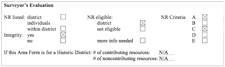
No properties within the Project Area are currently listed in the National Register of Historic Places.
Determinations of National Register eligibility have previously been made for the following properties in the vicinity of the Project Area: the Congregational Church (921 Main Street, 1/4/80); Holy Resurrection Orthodox Church (Petrograd and Russian Streets, 5/16/79); Mt. Jasper Lithic Source (1.5 miles northwest of the confluence of the Dead and Androscoggin Rivers, 5/29/92); and St. Anne Catholic Church (58 Church Street, 5/29/79).
The New Hampshire Division of Historical Resources concurred with the finding that the Atlantic and St. Lawrence Railroad, with its contributing structures (the Grand Trunk Railroad Station, and the Green Street, Dead River and York Street bridges) is eligible for listing in the National Register.
Criterion A:
The Berlin Heights Addition Historic District is potentially eligible for the National Register under Criterion A in the area of community planning and development. This area was subdivided and developed by a group of local entrepreneurs during the population boom and immigrant influx that Berlin experienced. This neighborhood and its planning are an excellent example of private endeavors that took place in the urban planning of Berlin. An urban grid street pattern was laid down on the hilly terrain of the North Country to best utilize available space and to house the highest density possible. The plans and layout of this area were envisioned by a group of individuals and executed through the formation of a private corporation.
The Berlin Heights Addition is also an exemplary illustration of the speculative development that took place throughout the city, particularly in areas such as this that were targeted to house the immigrant and working class populations of Berlin. The immigrant population's mark on the landscape is illustrated by the number of three- story "French Blocks" that are found along Third Avenue, along with a Roman Catholic church and parochial school, as well as a Russian Orthodox church (both located just outside the project area).
The integrity of the original plan for Berlin Heights Addition is intact. The grid street pattern is in use, the area still maintains the same block and lot configuration and has been densely built up between 1892 and 1930. Little infill or demolition has occurred since the middle of the twentieth century. This neighborhood retains integrity of location, setting, design, feeling, workmanship, and association under Criterion A.
Criterion B:
The Berlin Heights Addition is not eligible under Criterion B. The significance of this neighborhood is the development of the area which was a cumulative effort among local entrepreneurs. Some of the individuals involved in the establishment of the Berlin Heights Addition Land Corporation were locally prominent citizens, including Herbert Goss, Frank Colby, and W.C. Perkins. Goss was involved in other development endeavors in Berlin around the same time this neighborhood began, including the local aqueduct company and the street railway. Colby, a local doctor, joined with Perkins to speculatively build some houses in this neighborhood. Perkins was a civil engineer whose firm drew the subdivision plans for the Berlin Heights Addition. Cumulatively, these men also founded the Berlin Heights Land Corporation, an earlier corporation with the same development goals as the Berlin Heights Addition, although it catered to the mill executives and professionals in Berlin rather than the working class and immigrant population. None of the individuals involved with the subdivision or development of the area lived in this neighborhood. This area is not eligible for its association with the group of individuals who planned the neighborhood; rather its eligibility is based on the broad pattern of community development.
Criterion C:
The Berlin Heights Addition Historic Area is potentially eligible for the National Register under Criterion C as a well-preserved example of a densely settled, variously developed, urban residential neighborhood typical of those laid out by private land corporations during the nineteenth century. The historic area is defined by the grid street pattern that joins the component parts together, the density of development, the physical relationship between built structures, the lack of uniformity among buildings and streetscapes attributable to the variety of developers over a thirty-year period, and the various building types that convey the neighborhood's mixed uses. The historic area is also significant for its collection of single and multifamily housing forms. These buildings serve to illustrate the evolution of urban housing forms in Berlin and the New England region. The neighborhood encompasses early multifamily tenements; single-family homes from various eras; two-family dwellings of various styles and forms, including Queen Anne, American Foursquare, and Colonial Revival; traditional regional three-story, three-family housing forms; and an important local variation, the French-Canadian block.
Though many of the individual structures within the area lack individual distinction, as a group the buildings and the overall setting make up a significant and distinguishable entity, historically and aesthetically united by a physical plan and pattern of development. The Berlin Heights Addition neighborhood is distinguished from the surrounding area by component property type, having a mixture of single and multifamily houses versus the exclusively single-family neighborhoods to the south, and the presence of commercial and small-scale industrial buildings as opposed to the strictly residential districts to the south.
The Berlin Heights Addition Historic Area retains the essential historical physical features that enable the neighborhood to convey its historic identity and significance. The historic area has integrity of location, remaining as an outlying satellite neighborhood to the downtown area, physically separated from the heart of the city by the Grand Trunk Railroad tracks and the Dead River. The geographic constraints presented by Mount Forist and the Dead River limited growth beyond that present at the end of the period of significance, preserving the historic boundaries of the initial land division. The Berlin Heights Addition retains a high degree of integrity of design and setting. The underlying grid pattern, which provides the most substantial element of design in the historic area, is intact. Defining topographic features such as the sloping landscape, rock outcroppings, and a ravine also remain unaltered. Instances of demolition in the neighborhood during or after the period of significance have been remarkably low. Similarly, there are few modern intrusions within the historic area. Most of these are new, single-family residential structures and modern commercial buildings located near the northern boundary of the project area. The retention of the grid and low occurrence of demolition or modern intrusions has resulted in the preservation of the physical relationships between buildings in the historic area, another significant element contributing to architectural significance.
The individual buildings within the historic area similarly retain sufficient integrity to convey the significance of the neighborhood as a densely settled, urban neighborhood developed in the late nineteenth and early twentieth centuries. The component buildings have a uniform level of integrity. All retain integrity of location, setting, and design. Among the component buildings in the historic area, there have been only minimal instances of major, character-altering additions or the demolition of large portions of buildings beyond the period of significance. Most of the buildings have suffered a loss of integrity of materials and workmanship due to the application of synthetic siding (including asphalt, asbestos, aluminum, and vinyl), window replacement; and the removal, addition, reconfiguration, or enclosure of porch structures. These changes are often the inevitable result of maintaining a building in a cold, harsh climate. The individual materials applied to each building, however, are less vital to the combined significance of the historic area than what the buildings contribute through form, massing, location, and relationship. The variety of designs and forms displayed among the two and three-family dwellings in the neighborhood speak more to the integrity of workmanship within the historic area than construction materials. These forms in the neighborhood and the important architectural features associated with them remain visible and recognizable, despite non-historic exterior treatments.
There are several buildings within the project area that are potentially individually eligible for the National Register under Criterion C. The 1926 Boulay Blocks, located at 844 and 848 Third Avenue, are exceptionally well-preserved examples of the French-Canadian block, an important local building form. Blocks are defined as three- story, three-family houses with flat roofs, significant exterior porch structures, and separate entrances to each unit. French-Canadian immigrants to Berlin conceived of the block as an economical, temporary housing form that allowed several generations or branches of a family to live together. The Boulay Blocks were constructed by French-Canadian immigrant Stephen Boulay, who owned a roofing and paving business in the neighborhood. The two buildings have all the hallmarks of the block form and retain a high degree of physical and environmental integrity. The early twentieth century multi-car garages constructed behind the Boulay Blocks are a significant component of these properties and retain a similarly high degree of physical integrity. Both blocks remain three-story, three-family buildings with a three- story wrap around porch included under the roofline. The buildings are located on the original lots on the northern end of Third Avenue, surrounded by other forms of multifamily housing. There have been minimal changes to the physical form or architectural features of the blocks since construction. The buildings retain clapboard siding, 2/2 windows, picture windows, storm window, and porch supports. The porch balustrades have been replaced on the block at 844 Third Avenue. Because of the high degree of physical integrity both of the Boulay Blocks retain the ability to convey the sense of an early twentieth-century French-Canadian block, and thus have integrity of feeling. Both buildings continue in residential use and therefore also retain integrity of association with a multifamily residential context. The Boulay Blocks retain a significantly higher degree of integrity than many other French-Canadian blocks observed in other neighborhoods of Berlin, most of which are located in the Forbush Park/East Side neighborhood. Many of these blocks have enclosed porches, synthetic siding, and replacement windows.
The ca. 1920 house constructed behind the buildings on Second Avenue (Block 11) at the intersection with the Grand Trunk Railroad tracks is also potentially individually eligible under Criterion C. This 13⁄4-story, single-family house is a well-preserved example of a vernacular sidehall form displaying elements of the Queen Anne style. Characteristics of the Queen Anne style include a combination of clapboard and wood shingle siding, wide frieze boards, cornice returns, and an overhanging section in the façade gable. The house retains integrity of location, setting, design, materials, workmanship, feeling and association.
The ca. 1901 Italianate two-family dwelling at 738 Second Avenue is also potentially individually eligible for the National Register under Criterion C. The 2-story building displays many of the defining characteristics of the Italianate style applied to a long, narrow urban housing form. Defining characteristics include the low-pitch hipped roof, overhanging eaves supported by scroll brackets, and classical features such as a pedimented single-story bay window and cornerboards ending with modest capitals at the eave line. The house retains integrity of location and setting. Integrity of design has been compromised by the addition of a two-story porch on the façade, the enclosure of the second story of that porch, and a later addition to the rear elevation of the ell. The house has integrity of materials and workmanship, retaining original clapboard siding and most of the original 2/2 window sash and flush surrounds.
Boundary Discussion
There are two potential eligibility boundary sets for the Berlin Heights Addition Historic Area. The first boundary set encloses the whole of the Berlin Heights Addition as laid out by the Berlin Heights Addition Land Corporation. These boundaries would include the area from the Grand Trunk Railroad tracks on the east to the rear lot lines on Sixth Avenue on the west, and from the rear lot lines of Mount Forist Street on the south to the northern ends of Fourth through Sixth Avenues as they meet Wight Street. Choosing this set of boundaries produces a district united historically by plan, but does not result in a district unified aesthetically or through physical development. The Berlin Heights Addition neighborhood as defined by its creators encompasses different areas of density and building character. The portions of the Addition north of Third Avenue are less dense, and Sixth Avenue is sparsely developed in comparison to the lower avenues. The portions of the neighborhood above Third Avenue and on the northern end of Wight Street also have a more uniform pattern of single-family housing, with few instances of multifamily housing and no commercial development.
The second set of potential boundaries for the eligible district encompasses those portions of the Addition unified by building character, density, and development pattern. These boundaries would include the area from the Grand Trunk Railroad tracks on the east to the rear (west) lot lines of Third Avenue on the west, and from the rear lot lines of Mount Forist Street on the south to the point at which Third Avenue becomes Wight Street on the north. This area contains a variety of single and multifamily housing, small-scale commercial development, and a level of density greater than that of surrounding areas near the Grand Trunk Railroad tracks. The area also includes important neighborhood civic and religious buildings such as the ca. 1916 Bartlett Primary School on First Avenue, the ca. 1929 St. Joseph's Parochial School and Convent, the ca. 1950 St. Joseph Catholic Church on Third Avenue, and the ca. 1895 Methodist Church on Mount Forist Street.
26. PERIOD(S) OF SIGNIFICANCE:
The period of significance for the Berlin Heights Addition is 1892 to 1930. This represents the period encompassing the planning of the neighborhood through the full realization of its grid development plan. The layout of its last streets, Seventh Avenue, Labossiere Street, and Hinchey Street, occurred in 1930. By this time construction in the area had significantly declined or stopped. The multifamily residences, in particular the "French Blocks" that distinguished the area were no longer being built. This also likely represents the peak in population of the area, and the peak of the area's cultural cohesiveness. Later years saw declines in population and loss of neighborhood shops and cultural institutions such as the parish of St. Joseph. Although transportation-related resources increased in the mid-twentieth century in the area, these are not significantly tied to the areas historic significance.
27. STATEMENT OF INTEGRITY:
The Berlin Heights Addition Historic Area retains integrity of location and setting. The neighborhood remains a satellite residential area to the downtown district, separated from the city center by the St. Lawrence & Atlantic Railroad tracks and the Dead River. The geographic constraints presented by the railroad, river, and Mount Forist limited growth beyond the 1892-1893 planned bounds, preserving the historic boundaries of the initial land division. Defining topographical features such as the sloping landscape, rock outcroppings, and natural ravine also remain unaltered. The Addition continues to exist as a predominantly residential neighborhood of mixed single and multifamily dwellings and small-scale commercial development. The area has lost some integrity of setting through the reduction in small business activity in the neighborhood during the late twentieth century. Many commercial spaces set in residential buildings no longer exist, and serve as residential units once again.
The Berlin Heights Addition Historic Area retains a high degree of integrity of design. The underlying grid pattern, which provides the most substantial element of design in the historic area, is intact, as are the vast majority of the original housing lots. There have been only limited instances of demolition of component buildings within the historic area during or after the period of significance. Similarly, there are few modern intrusions within the neighborhood. The combination of these factors preserves the relationships between component buildings and maintains the visual rhythms of the varied streetscapes.
The Berlin Heights Addition displays integrity of materials and workmanship primarily through the variety of forms of housing constructed in the neighborhood. The physical elements that combine within a particular pattern to make up the district, namely the buildings, remain largely intact as a group. The forms and plans the housing displays reflect the architectural design and building crafts of the late nineteenth and early twentieth centuries. Because there have been very few instances of demolition within the neighborhood and similarly limited instances of major reconfigurations of component buildings, the historic area maintains integrity of workmanship. Most of the individual buildings in the historic area no longer retain integrity of materials and workmanship beyond plan and form due to synthetic siding, replacement windows, and alterations to porch structures. These changes are often the inevitable result of maintaining a building in a cold, harsh climate. Integrity of workmanship and materials as it applies to each individual building is not a vital element of integrity within the overall district, however. The form, massing, and arrangement of component buildings within the neighborhood contributes more to the significance of the district than construction materials.
Finally, the Berlin Heights Addition retains integrity of feeling and association. The historic area maintains sufficient integrity of setting, design, materials, and workmanship to convey the sense of a turn-of-the-twentieth-century, planned urban residential neighborhood. The intact grid and lot system, survival of the majority of component buildings in a relatively unaltered state, and limited growth combine to create this effect. The area also continues as a primarily residential district, with small-scale commercial development scattered throughout.
28. BIBLIOGRAPHY and/or REFERENCES:
Anonymous
1904 City of Berlin Directory. Collection of the New Hampshire State Library, Concord, NH
Anonymous
1906 City of Berlin Directory. Collection of the New Hampshire State Library, Concord, NH
Anonymous
1910 City of Berlin Directory. Collection of the New Hampshire State Library, Concord, NH
Anonymous
1913 "Berlin, New Hampshire," in Illustrated Industrial Edition of Busy Berlin. Berlin, NH: The Franklin Printery. Collection of the New Hampshire State Library, Concord, NH
Anonymous
1923 City of Berlin Directory. Collection of the New Hampshire State Library, Concord, NH
Anonymous
1924 City of Berlin Directory. Collection of the New Hampshire State Library, Concord, NH
Anonymous
1927 City of Berlin Directory. Collection of the New Hampshire State Library, Concord, NH
Anonymous
1929 Berlin, New Hampshire, Centennial, 1829-1929. Edited by the Historical Committee.
Anonymous
1930 City of Berlin Directory. Collection of the New Hampshire State Library, Concord, NH
Anonymous
1932 City of Berlin Directory. Collection of the New Hampshire State Library, Concord, NH
Anonymous
1934 City of Berlin Directory. Collection of the New Hampshire State Library, Concord, NH
Anonymous
1936 City of Berlin Directory. Collection of the New Hampshire State Library, Concord, NH
Anonymous
1939 City of Berlin Directory. Collection of the New Hampshire State Library, Concord, NH
Anonymous
1941 City of Berlin Directory. Collection of the New Hampshire State Library, Concord, NH
Anonymous
1948 City of Berlin Directory. Collection of the New Hampshire State Library, Concord, NH
Anonymous
1950 City of Berlin Directory. Collection of the New Hampshire State Library, Concord, NH
Anonymous
1963 Facts and Figures ... City of Berlin, New Hampshire. Berlin, NH: Berlin Chamber of
Commerce. Collection of the New Hampshire State Library, Concord, NH
Anonymous
1979 City of Berlin, New Hampshire Sesquicentennial 1829-1979. Collection of the New Hampshire
Historical Society, Concord, NH
Arsdel, Van
1934 Berlin, NH Survey. Collection of the New Hampshire Historical Society, Concord, NH
Bacon, George F.
1890 Northern New Hampshire and Its Leading Business Men. Boston: Mercantile Publishing.
Collection of the New Hampshire State Library, Concord, NH
Bartlett, Otis
1985 "Historical Glimpses," in Reflections of Berlin. Berlin, NH: Berlin City Bank. Collection of the
New Hampshire State Library, Concord, NH
Berlin City Planning Board
1937 Preliminary Data for City Planning, Berlin, New Hampshire. Collection of the New Hampshire
State Library, Concord, NH
Berlin Heritage Trail Partnership
1997 "Heritage Tour of Berlin, New Hampshire." Published by Gulfside Press Design.
Bunker, Victoria, Jane Potter and Robert Goodby
1996 Technical Report: Archaeological Resources Phase I-A Preliminary Archaeological Assessment,
Portland Natural Gas Transmission System New Hampshire Reroute, CP 96-249-003. Prepared for Tenneco Energy, Houston, Texas.
Bureau of the Census
1850 Agricultural Census, Coos County. Microfilm collection of the New Hampshire State Library, Concord, NH
Bureau of the Census
1850 Industrial Census, Coos County. Microfilm collection of the New Hampshire State Library, Concord, NH
Bureau of the Census
1850 Population Census, Coos County. Microfilm collection of the New Hampshire State Library, Concord, NH
Bureau of the Census
1860 Agricultural Census, Coos County. Collection of the New Hampshire State Archives, Concord, NH
Bureau of the Census
1860 Population Census, Coos County. Collection of the New Hampshire State Archives, Concord, NH
Bureau of the Census
1870 Agricultural Census, Coos County. Microfilm collection of the New Hampshire State Library, Concord, NH
Bureau of the Census
1870 Industrial Census, Coos County. Microfilm collection of the New Hampshire State Library, Concord, NH
Bureau of the Census
1870 Population Census, Coos County. Collection of the New Hampshire State Archives, Concord, NH
Bureau of the Census
1880 Agricultural Census, Coos County. Collection of the New Hampshire State Archives, Concord, NH
Bureau of the Census
1880 Industrial Census, Coos County. Microfilm collection of the New Hampshire State Library, Concord, NH
Bureau of the Census
1880 Population Census, Coos County. Collection of the New Hampshire State Archives, Concord, NH
Bureau of the Census
1900 Population Census, Coos County. Collection of the National Archives Northeast Branch, Waltham, MA
Bureau of the Census
1910 Population Census, Coos County. Collection of the National Archives Northeast Branch, Waltham, MA
Bureau of the Census
1920 Population Census, Coos County. Collection of the National Archives Northeast Branch, Waltham, MA
Bureau of the Census
1930 Population Census, Coos County. Collection of the National Archives Northeast Branch, Waltham, MA
Bureau of the Census
1940 16th Census of the United States.
Casella, Richard M.
2001 Atlantic & St. Lawrence Railroad Area Form. On file at the New Hampshire Department of Transportation, Concord, NH
Casella, Richard M.
2002 Berlin Mills Railway Area Form. On file at the New Hampshire Department of Transportation, Concord, NH
City of Berlin
1898 First Annual City Report. Collection of the Berlin Public Library, Berlin, NH
Closs, Christopher
1997 "Preliminary Chronology of the Albert Theater and Environs." On file at the New Hampshire Division of Historical Resources, Concord, NH
Coos County Rural Areas Development Committee
1964 Continual Overall Economic Development Program for Coos County New Hampshire. Collection of the New Hampshire State Library,
Concord, NH
Davis, Bailey K.
1897 Traditions and Recollections of Berlin. Reprint published in 1989, Berlin, NH: Smith-Poley
Press. Collection of the New Hampshire State Library, Concord, NH
Dodge, Nancy
1985 Northern New Hampshire Graveyards and Cemeteries. Salem, MA: Higginson Books.
Eno, R.D.
1989 "Jews of Berlin, New Hampshire: A once thriving community vanishing" in Kfari, Vol. 2, No. 5.
Personal collection of Linda Upham-Bornstein, Berlin, NH
Federal Writers' Project/Works Progress Administration.
1938 New Hampshire: A Guide to the Granite State. Cambridge, MA: Riverside Press.
Hans Klunder Associates
1968 "Phase II of a Comprehensive Planning Program, Berlin, New Hampshire," in City of Berlin, NH
Master Plan 1964-1984. Phase II 1968. Collection of the New Hampshire State Library, Concord, NH
Heath, Kingston
2001 The Patina of Place: the Cultural Weathering of a New England Landscape. University of Tennessee Press.
Herndon, Richard ed.
1898 Men of Progress. Boston: New England Magazine Publishing. Collection of the New Hampshire Historical Society, Concord, NH
Krim, Arthur
1977 Three-Deckers of Dorchester (Massachusetts): An Architectural Historical Survey. Boston
Redevelopment Authority.
Louis Berger Group, Inc.
2001 Berlin Project Area Form. On file with the New Hampshire Division of Historical Resources, Concord, NH
Merrill, G. comp.
1888 History of Coos County. Reprinted in 1972. Somersworth, NH: New Hampshire Publishing Company.
Monroe, Lynne Emerson, Kari Ann Laprey, and T. Kirker Hill
1998 Berlin Town Project Area Form. On file with the New Hampshire Division of Historical Resources, Concord, NH
Morneau, Renney E.
1998 Berlin, New Hampshire. Charleston, SC: Arcadia Tempus Publishing. Collection of the New Hampshire State Library, Concord, NH
Moses, George H., ed.
1893 New Hampshire Men. Concord, NH: New Hampshire Publishing Co. Collection of the New Hampshire Historical Society, Concord, NH
Shand-Tucci, Douglass
2000 Built in Boston, City and Suburb 1800-2000. Amherst, MA: University of Massachusetts Press.
Shaw, W.E.
1886 Coos County Gazetteer. Collection of the New Hampshire State Library, Concord, NH
Stearns, Ezra S., ed.
1908 Genealogical and Family History of the State of New Hampshire. New York: Lewis Publishing Company. Collection of the New Hampshire Historical Society, Concord, NH
Upham-Bornstein, Linda
2001 "An Analysis of Voting Patterns in Berlin, New Hampshire from 1928 to 1938". Unpublished
(partial requirement for Ph.D. at UNH), from the personal collection of the author, Berlin, NH
Upham-Bornstein, Linda
2000 "La Survivance: The Shaping of French Canadian Identity in New England". Unpublished
(partial requirement for Ph.D. at UNH), from the personal collection of the author, Berlin, NH
Wight, D.
1967 The Androscoggin Valley: Gateway to the White Mountains. Rutland, VT: Charles E. Tuttle Co.
Maps
Anonymous
n.d. "Lot and Range Map of Berlin." Collection of the New Hampshire Historical Society, Concord, NH
Anonymous
1907 (revised 1923) "Berlin Lot Map." Collection of the Berlin and Coos County Historical Society, Berlin, NH
Anonymous
1920 "Map of Berlin." Collection of the Berlin and Coos County Historical Society, Berlin, NH
Hurd, D.
1892 Town and County Atlas of the State of New Hampshire. Philadelphia: D.H. Hurd & Co.
Norris, Geo. E.
1888a "Berlin Falls, NH and Berlin Mills." Bird's-eye. Collection of the New Hampshire State Library, Concord, NH
Pike, Perkins and Macy
1892 "Plan D of the property of Berlin Heights Addition". Collection of the Coos County Recorder of
Deeds (Deed Book 59, Page 210), Lancaster, NH
Pike, Perkins and Macy
1893 "Plan E of the property of Berlin Heights Addition". Collection of the Coos County Recorder of Deeds (Deed Book 64, Page 295), Lancaster, NH
Pike, Perkins and Macy
1893 "Plan E of the property of Berlin Heights Addition showing changes and additions to original plan". Collection of the Coos County Recorder of Deeds (Deed Book 64, Page 400), Lancaster, NH
Pike, Perkins and Macy
1893 "Plan F of the property of Berlin Heights Addition". Collection of the Coos County Recorder of Deeds (Deed Book 64, Page 398), Lancaster, NH
Pike, Perkins and Macy
1893 "Plan G of the property of Berlin Heights Addition". Collection of the Coos County Recorder of Deeds (Deed Book 64, Page 349), Lancaster, NH
Sanborn Insurance Co.
1901 "Berlin, NH". Collection of the New Hampshire Historical Society, Concord, NH
Sanborn Insurance Co.
1905 "Berlin, NH". Collection of the New Hampshire Historical Society, Concord, NH
Sanborn Insurance Co.
1909 "Berlin, NH". Collection of the New Hampshire Historical Society, Concord, NH
Sanborn Insurance Co.
1914 "Berlin, NH". Collection of the New Hampshire Historical Society, Concord, NH
Sanborn Insurance Co.
1920 "Berlin, NH". Collection of the New Hampshire Historical Society, Concord, NH
Sanborn Insurance Co.
1928 (revised 1955) "Berlin, NH". Microfilm Collection of the New Hampshire State Library, Concord, NH
Sanborn Insurance Co.
1938 (revised 1950) "Berlin, NH". Collection of the New Hampshire Historical Society, Concord, NH
Tankard, E.E.
1949 (revised 1954) "Berlin, NH". 1956 Berlin City Directory. Collection of the Berlin and Coos County Historical Society, Berlin, NH
Walling, H.
1861 "Map of Coos County, NH." New York: Smith, Mason and Co. Collection of the Berlin and Coos County Historical Society, Berlin, NH
Newspapers
Berlin Independent
1888-1908 Microfilm Collection of the New Hampshire State Library, Concord, NH
Internet Resources
Interviews
Lavertue, Maurice, Jr., Vice-president of the Moffett House Museum/ Berlin & Coos County Historical Society, November 2002.
Leclerc, Odette, Director/Curator of the Moffett House Museum/ Berlin & Coos County Historical Society, November 2002.
Upham-Bornstein, Linda, local historian, January 2003.
Historic Photographs
Berlin and Coos County Historical Society, Berlin, NH
Deeds
Coos County Courthouse, Lancaster, NH